Rothar Routes

Cycle routes & pilgrim journeys in Ireland and Europe …..

Posts from the ‘Routes’ category

Old Carlow Walking Trail – Where were we?

What else would you be doing on a Bank Holiday Monday only going for a ramble. Seeing as we can’t leave our 5kms zone, we decided instead to indulge in some time travel. What was the town like in previous centuries?

I wonder can you identify where we were? If I have wrongly identified old names forgive me! Most of the detail here was from some articles my father had put together while researching the location of the old walls of Carlow Town..

I’ll pop in some visual clues as we make our way to help identify where we went.

We confined ourselves to the Town Centre, starting in Tullow Street with our first place of interest, a licensed premises and hotel since 1768, still bearing the same name! Formerly known as ‘The Farmers Inn’.

1768!

Across the road is the premises, ‘The Plough’, only in existence since 1829! There was a hotel in Tullow Street called the Plough Hotel, presumably on the same site.

1829!

I’ve often been in Lowrys Lane without realising it as I called to the family run hardware opposite the ‘Beehive Hut’ ….any takers?

A window looking near Lowry’s Lane.. or thereabouts!

Passed quickly by the Old RIC Barracks and then tried to book a room in the Commercial Hotel but couldn’t find the entrance! Anyone got an idea where this hotel was once to be found? Served as a famous ballroom for many years in a later life..

RIC Barracks was here

We took a small u turn to bring us around to Cockpit Lane….

Cockpit Lane

In 1986 Éire Óg produced a great local history ‘Friends and Neighbours’ that researched over 500 families that lived along a number of streets in Carlow Town. At the heart of it all was Bridewell Lane and Brewery Lane. Bridewell Lane, so called because it led to the Gaol, was largely demolished and sadly there is no trace of Brewery Lane. But folk memory is great and thanks to interviews with many of the families a great picture of the area can be ascertained from the descriptions and family photographs.

Source ‘Friends and Neighbours’

All the houses were whitewashed and had half doors with lots of music and singing.

We are now in the heart of old Carlow; Bridewell Lane was formerly known as Somers Lane.

Leaving Bridewell Lane we pass by the Sessions House – used to be the Crown and Record Courts and we slipped onto the Strand!

The Sessions House
Windows on The Strand…..what is the current name of this street?

From the Strand we strolled down Coal Market , where once coal was sold …. and much more besides; Swans Electrical started out down here..

The Moneen was an area between the old Town and the Castle, prone to flooding at the time of the building of the Castle. In more recent time and, for many years, locals visited John Flynn for a cure for warts on this laneway which brought us towards Skinners Lane and Wellington Quay..

Wellington Quay
Entrance to Skinners Lane?

Leaving the east bank of the Barrow we crossed over Wellington Bridge

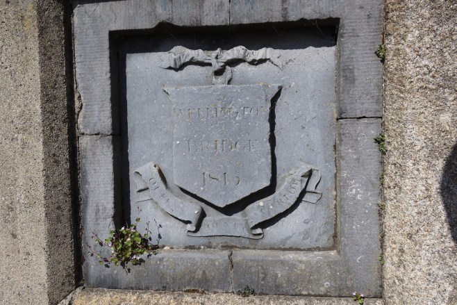
and continued onto Batchelors Walk…

It was a short hop onto Barrow Street and Morrins Lane

When Cromwell came to Ireland he ordered the Irish to ‘hell or to Connaught’… I wonder did he mean Connaught Lane?

Is the entrance to the Town Park Connaught Lane?

Back on the east side of the Barrow we made our way up North Cotts Lane towards Dublin Street…

We retraced our steps back to South Cotts Lane and Fairy Lane / Templecroney Lane…Templecroney commemorates Naomh Croneybeg..

Surely the most unusual name of any street in Carlow must have been ‘Labour-In-Vain Lane’, which took its name from a sign on a tavern representing a person trying to wash a blackman white….I kid you not! From there we made our way back onto Dublin Street where we sought to find The Bear Inn which was located at no 64 Dublin Street. The Red Cow Inn which was located across the road at no 2 Dublin Street…

Further up the street we sought out the Blackamoor Inn, 58 Dublin Street and the Crown and Sceptre, 59 Dublin Street – taverns from the 1700s….

It was time to start making our way back home and we took a peek at the house where The Globe Inn was located in the 1600s and where, wait for it, King James stayed briefly after the Battle of the Boyne.. a wall plaque displayed the initials of WJR (though it looks like WIR to me) 1699 which reference the then owners Jonathan and Ruth Watson..

We then went via Cuckoo Lane, or should I say Hunt Street, and tried to get a meal in the Imperial Hotel but there was no one serving..

Hunt Street, formerly known as Cuckoo Lane and now known as …?
The Imperial Hotel ??

A right turn on to Mass House Lane and back into Tullow Street to finish a lovely afternoon walk with a difference..

An image on Mass House Lane…. now known as …?
Love this modern masterpiece..

I referenced the ‘Friends and Neighbours’ Booklet earlier. Sadly it is out of print but it is a brilliant example of local history which was complied by a FÁS teamwork scheme back in 1986. The Committee overseeing the publication was Dermot & Kathleen O Brien, James Brady and Nancy O Brien. Researchers were Adel Delaney, Karen Doran, Nuala Foley, Joan Gaffney, Robert Hayden, Sandra James, Jo Kirwan, Esther Moore, Karen O Hagan and Eithne Ware. I wonder could it be reprinted? I’m sure lots of people would like to have a copy.

5k Back to the Future

Before the advent of mass produced bicycles at the end of the 19th century, most people would not have ventured beyond their parish, whether in the countryside or in the small towns of the provinces.

Work would have been local, socialising would have been confined to the village hall and tavern and spare time activities included visits to rambling houses for story telling, dancing at the cross roads, playing caid or hurling, a bit of fishing or hunting. And that was probably about it. A simple existence. A hand to mouth existence for most.

Romance was confined to the local population and outsiders were few and far between.

I often think of one of the stories Peig Sayers recalled of ‘the old hag’ who decided to travel from Corca Dhuibhne to Dublin. She set out from Dun Chaoin but when she got over the hill at Sliabh an Iolar she was shocked at the extent of the country side spread out before her and she turned around and never again thought of leaving her local surroundings.

Travel to larger towns or cities was very difficult and lengthy – only a privileged few would have made it to Dublin.

Night cycle to Ducketts Grove

One of the factors that brought social change was the arrival of mass produced bicycles. It extended the range of peoples horizons; for many it was the mode of transport and we all have heard the stories of football and hurling supporters cycling the Dublin from places like Carlow and Portlaoise for Championship games – and home again!

The arrival of Covid-19 and 5kms travel restrictions brought this into focus for me as we found ourselves in lockdown, confined to our own areas, just like previous generations before us. And it was strange and hard to adapt. One business that has boomed since Covid arrived has been the Local Bike Shop. Sales of new and second hand bikes have gone through the roof. Imagine there are waiting lists for new bikes!

Day time visit to Ducketts Grove!

There are a few positive knock ons from Covid – it’s not all doom and gloom and it will be interesting to see if the effect lasts when vaccines are widely available and we get a return to the old normal; but in the meantime people are rediscovering there own localities, the pace of life has slowed down, more people are exercising – especially walking and cycling. People are looking for new routes all the time. There is less commuting with many people working form home. And people are liking what they are experiencing.

Myself and Mary have never done as much cycling, even though we are limited in where we can go; but we have not allowed weather or darkness stop us from getting out for fresh air, exercise and some exploring and rambling around Carlow and environs.

It has been great to see families out together on their bikes, along the fantastic network or local roads that are very safe for cycling. Here’s hoping it continues as we get a sense of what our forefathers experienced 100 years ago!

2020 Hike & Bike

The strangest of years in living memory saw us rediscover our own country in 2020. Fear, worry, stress, anxiety were all our bedfellows as we wondered where the invisible enemy would strike next. Travel was restricted, social contacts likewise and to get away from it all we sought out the quiet places.

We escaped into nature. It’s amazing how much the most popular trails have deteriorated during lockdown as people took to the outdoors for exercise, fresh air and their sanity. Luckily we have lots of green spaces on this beautiful island of ours.

As soon as lockdown was lifted I found myself heading away almost every evening to somewhere new.

I’ve covered over 1500 kilometres since March on my bike. All of it on quiet country roads or off road along the Barrow Way, the Grand Canal, the Royal Canal and a myriad of cycle trails. Counties cycled in this year were Carlow, Laois, Kildare, Wexford, Kilkenny, Offaly, Westmeath, Longford, Meath, Galway, Roscommon, Clare, Tipperary, Cavan, Fermanagh, Monaghan, Armagh and Down, 18 counties in total! All beautiful and all equipped with that network of rural roads that are safe and a joy to cycle on. I’ve donned hiking boots to visit Máméan in Connemara, the Devils Bit, Slievenamon, the Blackstairs, Ballycumber and Askamore to name but a few.

I’ve made a short video above of some of the sights we saw in our travels. Many thanks for following my blog during 2020 and I hope it brought you some enjoyment.

Happy New Year to all!

Escape to Kilkea

With a raging pandemic in full flow, the thoughts of Christmas shopping fill me with dread. I seem to have missed the warnings today of imminent food shortages and empty shelves judging by the full car parks in Town this morning.

Kilkea Castle from back entrance

The entire country seems to have finally discovered all the great walking trails and loops dotted across the country, judging by the worn paths at this time of year and so are often a little too populated for my liking at this time. The great thing about the bike is it increases your range and your options. Today was a day made for the bike; a blue sky, little wind and the air was crystal clear. Cool but an incredible Sunday in December. An Escape from the madness.

Kilkea is almost directly north of Carlow Town and there’s a spiders web of tiny quiet roads that are just perfect for cycling – I can count on one hand the number of cars met over 32kms cycling. I take the road out through Oak Park, behind the Golf Club and turn left at Ballaghmoon Cross. Thats the first 5kms done! It’s a straight road for the next couple of kms followed by two right turns. Take the second right and continue over the Maganey – Castledermot road at Castleroe Crossroads. The surfaces are great, the roads are quiet and there are great expansive views across the lowlands of south Kildare. After another kilometre, take the left fork in the road and enjoy the freewheeling down the hill before turning right onto a beautiful tree lined stretch that finishes with a stunning view of Kilkea Castle at the T-junction. Take a left into pretty Kilkea village and tuen into the grounds of Kilkea Castle.

It’s a stunning twelfth-century castle, home of the Fitzgeralds, Earls of Kildare. The castle is again a top-class hotel and golf resort for many years, having fallen victim to the economic downturn post-Celtic Tiger but is now open. It has an enchanting history – associated with ‘The Wizard Earl’ who practised alchemy and was reputed to have magic powers. They say the castle is haunted and that he returns every seven years on a white horse!

Kilkea Castle

Another claim to fame for Kilkea is that it is the birthplace of the Antarctic explorer, Ernest Shackleton, and there’s a really great statue in nearby Athy in his honour and also a fine Shackleton museum in the Athy Heritage Centre.

After a few photos it was time to head back home and I took the back road out of the Castle and crossed over at Sills Cross, up the hill returning as far as the fork in the road where I had taken the left fork on the way out.

Back at Castleroe Cross I swung left in the direction of Castledermot and took the right at the top of the hill. It’s another great road, well surfaced and quite wide. I took a right after 2kms approx onto a minor road which brought me back to Ballaghmoon Bridge from where I returned along the route I took out of town.

Total distance: 33kms. Time (including stops) 1hr 54mins. Moving time 1hr 38 mins. Highly recommend this route!

https://ridewithgps.com/trips/60479019

Famine

The Hunger – Over 1,000,000 dead of starvation and disease, 1,250,000 emigrated…

Over the course of the summer, I had the good fortune to be able to spend some time cycling along the banks of The Royal Canal.

The path doubles as the National Famine Walk – a walking route that commemorates ‘the poignant ill-fated story of assisted emigration in Ireland during the Famine in 1847 when 1,490 poor and hungry were forced to walk the 165km from the Strokestown Park Estate, County Roscommon to Custom House Quay in Dublin. They travelled onward to Liverpool and almost a third of them perished crossing the Atlantic in “coffin ships” bound for Canada’.

I had been on the Canal before and had spotted a most unusual way marker:

National Famine Way Marker

A pair of children shoes. It shook me to my core. As I progressed northwards I saw more of these markers and my journey morphed from a cycle along the Canal to a pilgrimage to Strokestown to visit the National Famine Museum. It is well worth a visit and all the better if you complete the Way.

The two episodes of the documentary ‘The Hunger’ have brought the incredible affect of the Famine into the living rooms of the country and set out in no uncertain terms the scale of death, destruction and devastation inflicted on a peasant people.

The wonder is how we as a nation have rebounded so well from such deep trauma to our psyche. The Irish people have shown their resilience and their abilities – abilities that were denied by our rulers and we should be proud of the nation we have built.

But we should not forget the cruelty inflicted on a suffering people. And I don’t mean remember it in terms of rabid nationalism, I mean in terms of our humanity to other peoples who, incredibly in this day and age are suffering the same fate; arriving on our shores only to often be met with indifference and sadly sometimes worse – downright hostility by people who have forgotten our past and are exploiting our present difficulties.

A picture paints a thousand words. Here are a few images from my cycle along the National Famine Way, a mural in Strokestown of a school project about the Famine and from the exhibits in the National Famine Museum.

Never forget.

Map of the National Famine Way
National Famine Way marker near Enfield
A famine pot in Abbeyshrule
List of persons to get MEAT on Christmas Day
Famine Pot in National Famine Museum
Ration tokens during the Famine
Eviction Crowbar used to dismantle roofs of cabins
School Project Strokestown
National Famine Way Marker near The Downs, Co. Westmeath
Strokestown Park, Roscommon