Rothar Routes

Cycle routes & pilgrim journeys in Ireland and Europe …..

Posts tagged ‘Borris’

Stay in Your County!!

Hard to capture it all!

I struggle with the logic of travel within your own county given the disparity in sizes between the smallest and the largest but at least it gives us a little more freedom! Today after months of 5kms restrictions today was the first day to seek out new horizons and to get out into the south!

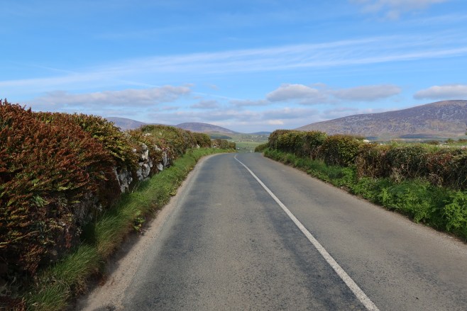
What a joyful 30kms cycle in the Deep south of Ceatharlach! We really have a beautiful little county and we don’t even know it too well ourselves.

Has to be Pat Hickeys house!

If you want to spend an afternoon or a day away from crowds, in splendid isolation, look no further than Rathanna as your base. I always approach it coming from Killoughternane side and the view that hits you as you round the bend at Tomduff matches anything in Ireland. It compares favourably with the views across to the Three Sisters from Slea Head in my books. Its a patchwork of 40 shades of green underneath the heathered slopes of The Blackstairs Mountain Range.

Moove over Mary!

Its always nice to know the local place names; each county has its own unique landscape and the descriptions are often in the place names. Irish place names are so poetic – Ballyglisheen, Rathgeran, Slievedurda, Rosdellig, Rathanna, Ballymurphy, Knockymulgurry, Knock, Gowlin…

Knockroe in the background

Traffic free narrow lanes make this route a smashing cycle route with a nice bit of climbs along the way to keep you honest… nothing major but a few nice pulls. And did I mention the scenery? Ah my God…

Traffic free laneways – just keep an eye out for the farm animals!

Or the hurlers? Down every by road are the famed Rangers and St Mullins camán wielders, territories marked out by red and black or green and white flags.. there must be great banter here around County Final time…

The more I cycle the more convinced I am that instead of investing millions in greenways, we should concentrate instead on creating dedicated cycle routes using the extensive local road network that links our isolated villages and parishes. It would cost an awful lot less and would not entail further damage to our biodiversity or result in the creation of more hard surfaces than we need.

Not a drop of milk in any of them…
Roads full of promise
And the Lamb did follow her!
Gowlin

Video link https://youtu.be/T4wmF1syKJQ

The Hidden Sky Road

Delighted to see Carlow County Council have signposted one of my routes, ‘The Hidden Sky Road’ which features in my book ‘Cycling South Leinster, Great Road Routes’.

Its a beautiful route to complete on a summers evening at just 37kms length featuring a small climb with stunning views across County Carlow.

The route begins in Borris, passing alongside the Mountain River and out of the village under the Viaduct, heading towards Rathanna.

Borris Viaduct with Mary

Wouldn’t it make a great section of a Greenway?

The Mountain River

The Mountain River is my favourite river in the County; wild with contrasting colours of brown, gold, yellow and green. Crystal clear water.

Quiet roads with lots of great vantage points to see the Blackstairs Mountains and Mount Leinster as you head east. There are lots of little known gems to stop off and and explore along the way.

With a little searching there are a couple of examples of rock art on the route (you will need permission to access) at Spahill and Coolasnaughta.

Spahill Rock Art

Coolasnaughta Rock Art

Carlow has a brilliant network of local roads that are virtually traffic free and ideal for cycling

Quiet Country Lanes near Rathanna

Views on The Hidden Sky Road

Tomduff

There are lots of heritage sites dotted across the county and some worth visiting close to the route not far from Tomduff Cross are

The White Church, Killoughternane

Rathnageeragh Castle

St Forthcern’s Well

Templemoling Cemetery

But the best views are from on high along The Hidden Sky Road

The Hidden Sky Road

View from The Hidden Sky Road

Blackstairs Horses in the Morning Mist

Wild horses Blackstairs

The Adelaide Memorial Church of Christ The Redeemer in Myshall is an architectural masterpiece. Worth a visit on its own. There’s a great love story about its construction which was built to commemorate the daughter and wife of a visiting English man. His daughter had been thrown from a horse while riding and died from the fall. The full story can be read in the Myshall and Drumphea Parish website

Adelaide Church Myshall

Ballynasillogue Banshee Stone is a little off the trail but worth checking out. Incidentally I would advise bringing a good map along with you on any of these routes; the best map by far is actually produced in Carlow by East West Mapping of Clonegal – ‘Blackstairs, Mount Leinster & The Barrow Valley at 1: 25,000 scale, it is full of so much detail and local knowledge.

Ballynasillogue Dolmen

It may be just a small corner of the county but as you can see there’s plenty to look out for and it might take a few trips to visit them all.

Finish up back in Old World Borris and a visit to two of Carlow’s iconic pubs

Joyce’s Bar Borris

O Sheas Borris

Wild Carlow

Water Pump at Tomduff Cross in the colours of Mt Leinster Rangers

Water Pump at Tomduff Cross in the colours of Mt Leinster Rangers

Ruins of Kiloughternane Church

Ruins of Kiloughternane Church

Mount Leinster on fire one fine summer's night

Mount Leinster on fire one fine summer’s night

Wild Carlow

This is not an established route but I aim to make it one!

I havent done all of this 135kms loop of County Carlow but I will in the summer.

This route has many outstanding features:

Route description.

Leave Carlow taking the Barrow towpath which you follow all the way to St Mullins.

This is obviously flat the whole way down but that’s no harm with what has to come later!

The Barrow Towpath is beautiful and differs from Canal walking as it is a follows the meanders of the River. It’s a gem of a mtb trail on a fine summer day. And there are significant places of historical and religious importance such as Leighlinbridge, Borris, Graiguenamanagh and the monastic site at St Mullins.

Leaving St Mullins talk a short road section before climbing up onto the ridge of the Blackstairs. This is a well known walking trail along the Carlow – Wexford border. Continue across the Scullogue Gap and rise up to the peak of Mount Leinster, the highest point in Carlow and Ireland’s fifth highest mountain.

Take the road down to the Nine Stones and follow it across to the t junction. You are now on the Sth Leinster waymarked Way. You will shortly go off road again and rejoin the trail which you follow to Kildavin. Take the road to Clonegal village and Huntingdon Castle.

Look for signs to the Wicklow Way, again on quiet roads. After about 6 kms you leave the road for a beautiful short section through wooded hillside on the famous Wicklow Way.

We leave the Wicklow Way to go to the ruins of Aghowle Church.

The area from the Blackstairs to here is where Columbanus is said to have been born.

After Aghowle we follow winding lanes to Ardattin and the bridge on the River Slaney at Agahde – a nice place for a picnic or a swim.

Time to head back to Carlow now and we again keep to the back roads and follow the route over by Kellistown Church ruins and into Carlow Town.

This has the potential to be a mega route with a little bit of mapping and signposting.

%d bloggers like this: